


To improve geophysical survey and site investigations, the Mines and Geosciences Bureau – Regional Office 7 (MGB-7) conducted a rigorous training of their technical personnel.
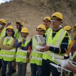
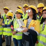
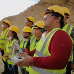
After acquiring a powerful version of an unmanned aerial vehicle (UAV) commonly called as a drone, the MGB-7 technical personnel were given a two-day orientation for the proper handling of DJI Phantom 4 V2.0.
Taking advantage of available technology, MGB-7 monitoring and investigations will be enhanced. The drone’s ability to capture images in low altitude at a controlled speed can make geological surveys, slope monitoring, field mapping among other research or investigation purposes may be easier.
On January 30-31, 2019, Senior Geologist Vida Vanessa Sangcal conducted the orientation and training to the regional office staff and personnel on how to use the drone technology.
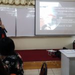

The lecture included an introduction of the use of the UAV, safety guidelines for drone operation as well as the Basic Air Law of the Philippines based on the Civil Aviation Regulations of the Civil Aviation Authority of the Philippines (CAAP).
Sangcal attended the Basic Course Training and Demonstrated Knowledge on safety, rules and regulations in operating DJI Phantom 4 Professional V2.0 at the MGB- Central Office in Diliman, Quezon City conducted in November 2018.
All the participants of the training had to use the DJI Simulation, determine the flight path for the aerial surveys as well as the basics of flying to collect real-time visual data.
The acquisition of the drone provides geologists and mining engineers access to hard to reach or dangerous areas. Critical or illegal quarry or mining operations can be monitored without prejudice to the safety of mining engineers investigating the activity while geologists can have easier access to vertical or overhanging geologic structures or unstable areas.
This technology can also help in the post disaster management to survey and monitor affected areas.